Truckee Canal History & Significance
History and Significance
The Truckee Canal is a critical component of the Newlands Project, one of the first five federal irrigation projects authorized under the 1902 Reclamation Act. This act marked a transformative moment in U.S. history, signaling the federal government’s commitment to reclaiming arid lands in the American West for agricultural use. The Truckee Canal, constructed between 1903 and 1905, was among the earliest efforts to implement this vision.
· Strategic Importance

Photo 1 - Derby Dam Opening
The canal begins at Derby Dam located on the Truckee River and stretches 31 miles southeast to the Lahontan Reservoir, traversing Storey, Lyon, and Churchill counties. In addition to providing water delivery in the Fernley area, the canal's primary function is to divert water from the Truckee River and supplement Carson River flows in providing for irrigation in the Lahontan Valley, enabling the transformation of desert into productive agricultural land. Completed in 1905, Derby Dam was the first dam constructed by the U.S. Reclamation Service (now Bureau of Reclamation) and serves as the headwaters for the Truckee Canal.
· Engineering Achievement
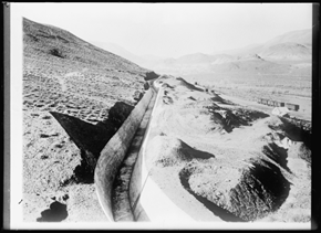
Photo 2 - Concrete Section of Truckee Canal
The Truckee Canal was a major engineering feat for its time, showcasing early 20th-century innovation in water conveyance infrastructure. The canal features both concrete-lined and earthen sections, designed to accommodate varying terrain and water flow requirements. To navigate the rugged topography between Derby Dam and the Lahontan Reservoir, engineers incorporated three tunnels that allowed the canal to pass through hills and other natural obstacles. In addition to these tunnels, the canal includes multiple spillways, check structures, and takeout gates that regulate water flow and distribution to agricultural lands. These control features were essential for managing seasonal variations in water availability and preventing overflow or erosion.
Remarkably, the canal’s alignment has remained largely unchanged since its original construction, a testament to the foresight and durability of its design. Over the years, maintenance and upgrades have ensured its continued operation, but the core engineering principles laid out during its initial construction have stood the test of time.
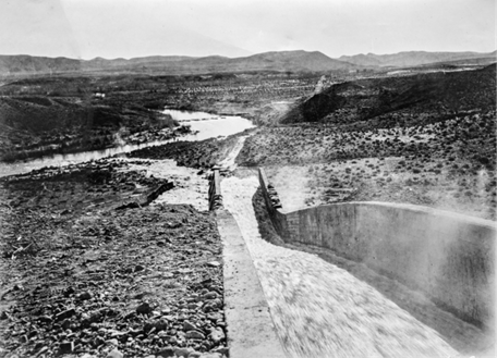
Photo 3 - Truckee Canal Chute Feeding Water into the Carson River

Photo 4 - Construction of Truckee Canal
· Catalyst for Agricultural Development
Before the canal, agriculture in Nevada was limited by the state’s arid climate and sparse water resources. The Truckee Canal enabled the irrigation of tens of thousands of acres, supporting crops such as alfalfa, potatoes, grains, and melons, and fostering the growth of dairy and livestock industries. By the 1920s, the project had helped convert over 70,000 acres of desert into fertile farmland.
Despite early setbacks, including droughts, floods, and the absence of a drainage system, the canal’s impact grew steadily, especially after the completion of the Lahontan Dam in 1915. The dam provided year-round water storage and delivery, stabilizing the irrigation system and enabling more consistent crop yields. The formation of the Truckee-Carson Irrigation District in 1918 further improved water management by addressing drainage issues and giving local users more control over operations.
Initially, farmers focused on alfalfa, a hardy crop well-suited to the region’s conditions and valuable as cattle feed. Over time, they diversified into potatoes, grains, hay, and melons, with some experimenting with sugar beets. Although a sugar beet factory was built in 1911, the crop proved difficult to grow consistently, and alfalfa remained the dominant product.
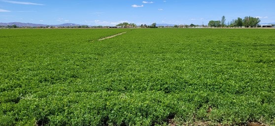
Photo 5 - Field in Production
The canal also supported the growth of the local dairy and beef industries which became increasingly important to the local economy. By the mid-20th century, the region had established itself as a significant agricultural hub, with most of the irrigated land dedicated to corn and alfalfa for livestock feed.
In essence, the Truckee Canal was not just a water conveyance system, it was a transformative force that reshaped the economy, settlement patterns, and agricultural potential of western Nevada.
While the canal brought prosperity to many settlers and farmers, it also had some negative consequences. The diversion of water from the Truckee River reduced flows into Pyramid Lake, impacting the Pyramid Lake Paiute Tribe whose livelihood depended on the lake’s ecosystem. This led to decades of legal battles over water rights and environmental justice. Those disputes have largely been settled with water uses becoming much more balanced and normalized.
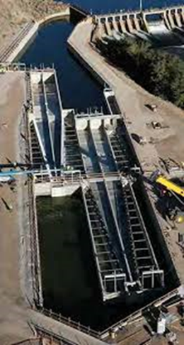
Photo 6 - Aerial of Fish Screen
One major step taken to reduce the environmental impact of the Truckee Canal was the construction of a modern fish screen at Derby Dam. Completed in 2020, the fish screen prevents native fish species, particularly the endangered Lahontan Cutthroat Trout (Oncorhynchus henshawi) and Cui-ui (Chasmistes cujus), from being diverted into the Truckee Canal. This project was implemented by the Bureau of Reclamation as a mitigation measure to address the environmental impacts of the canal diversion system.[1]
The Truckee Canal remains in operation today and is maintained by the Truckee-Carson Irrigation District. It is a remarkable piece of infrastructure that continues to serve its original purpose while standing as a monument to early federal reclamation efforts.
PHOTO DESCRIPTIONS AND CREDITS:
Photo 1: Derby Dam and Truckee Canal opening celebrations in 1905, showing Truckee Canal headwaters in bottom left with concrete and stone lining and original concrete-lined spillway on bank of canal.
Source: Congressional Party Gathered in Circle During Speaking at the Opening of the Truckee-Carson Project at Head of Main Truckee-Canal,” 17 June 1905, Photograph 169, Folder 32, Series JQ, Nevada Project – Nevada, Prints: Irrigation Projects, 1896-1936, Box 116, Records of the Bureau of Reclamation, Record Group 115, National Archives, College Park.
Photo 2: Truckee Canal showing concrete-lined section along Derby Reach, east of the affected section at Derby Dam, 1912.
Source: Reclamation, Bureau of. Truckee-Carson Project, Nevada; Canal Carrying Truckee River to Reservoir, Harris & Ewing, photographer, 1912, Photograph No. LC-H261-3342 [P&P], Harris & Ewing Photograph Collection, Library of Congress Prints and Photographs Division, Washington, D.C. Note: Harris & Ewing Photographs at Library of Congress, including this image, have no known publication and rights restrictions.
Photo 3: Truckee Canal Chute feeding water into the Carson River looking in the direction of the future location of Lahontan Reservoir taken in 1911.
Source: Carson Project No. 1- No. 25, c. 1911, TCID Box 1 Photographs Negatives File #1-100, on file at Truckee-Carson Irrigation District, Fallon, Nevada, Photograph No. 19, January 22, 1911, Folder 8:
Photo 4: Undated photograph of Truckee Canal during construction.
Source: Reclamation Service, Untitled Photograph of Truckee Canal, No. 58, n.d., TCID Box 3 Photo Albums, on file at Truckee-Carson Irrigation District, Fallon, Nevada.
Photo 5: Photograph of field in the Newlands Project
Credit: Ben Shawcroft
Photo 6: Fish Screen
Credit: Farmers Conservation Alliance
[1] In preparation of the construction of the Derby Dam Fish Screen, a Historic American Engineering Record was written from which much of the information contained in this summary was taken. The full document may be found by following this link:
Truckee Canal_Heritage Archival Documentation